Category Archives: Graubünden

Après-Ski 2010 | Rückwege Blog

https://silvrettahistorica.wordpress.com/2017/01/13/apres-ski-2010/

An era coming to an end? Alpine archaeology will never be the same again!

So, that’s that. Last week I had the honour and immense pleasure to help dig a few trenches at Las Gondas in the Fimbertal, between the Lower Engadin and Paznaun valleys. The Rückwege project was initiated by Thomas Reitmaier in 2006 and this might or might not turn out to have been the last ever field season. 10 years of multi-disciplinary and highly successful alpine archaeological fieldwork have come to an end. It was a fantastic time and a great week away from the PhD. A week in which a wonderful group of archaeologists and friends, who have all been involved in the project over the years, got together to excavate a system of animal pens in the beautiful Fimber valley. We managed to sort out the stratigraphy and expect it to be prehistoric, perhaps chronologically comparable to the Iron Age hut ruins we excavated further down the valley. But, as so often in the Alps, finds are scarce. So, we’ll have to wait for the 14-C dates to come back.

I would like to thank my friends, and especially Thomas, for their companionship, the laughs, the snoring, the Streusel, the EIER, the Schnapps, wine and beer, the snow, Lassiter, the tons of charcoal and the many buckets full of dirt and stone. Do have a look at Thomas’s post on  the Silvretta-Historica blog, which I’ve linked to below as well!

 sodalla – wir sind also schon wieder gut zurück aus dem schönen fimbertal und einer sehr erfolgreichen einwöchigen grabungskampagne im gebiet las gondas  … . das hauptanliegen, die dortigen pferchstrukturen genauer zu untersuchen und hoffentlich im verlauf der nächsten wochen auch mittels 14c-datierungen zeitlich einzuordnen, haben wir mit einem ausgezeichneten und hochmotivierten grabungsteam problemlos erreicht, trotz der mitunter etwas widrigen wetterbedingungen …    (CLICK ON THIS LINK TO THE SILVRETTA-HISTORICA PROJECT BLOG FOR MORE INFO AND LOTS OF GREAT PHOTOS FROM THE FIELDWORK!)

Filling some gaps – Recent research into the Mesolithic in the Swiss Alps

It was a scorching hot day in June 2014 in the Italian Dolomites. Now it is Febuary 2016. It is cold and dark out and I can’t wait to get on skis again. Still, it is a good day to think back on that hot June day when Thomas Reitmaier and I presented the results of a decade or so of Mesolithic research in the Alps of south eastern and central Switzerland at the MesoLife conference in Selva di Cadore. It is now available online!

Now you might think, is there any evidence for Mesolithic hunter-fisher-gatherers in the inhospitable high Alps? Well, yes there is. Up to 2007 hardly a handful of surface and loose finds were known. But many hours of dedicated fieldwork by many people have resulted in quite some new information. Thomas and I have tried to pull it all together and write it up. We were not only able to give a good impression of what we know of Mesolithic life in this part of the Alps, but also of what we do not yet know and what is to be done about that!

We are very excited that the corrected proof of the article is now available online as a preprint. So, get in your lazy chair in your snug warm room with a hot bevvy or a beer, look out on the wintery world outside and read all about the marvelous lives of people in the Alps 11’000 – 7’500 years ago. As you do, please also spare a thought for the archaeologists who spend days in rain, fog, sunshine and snow, with or without us, plodding across alpine meadows, climbing obscure passes and help dig innumerable – often empty – test-trenches.

Cornelissen, M., Reitmaier, T., in press. Filling the gap: Recent Mesolithic discoveries in the central and south-eastern Swiss Alps, Quaternary International (2016), http://dx.doi.org/10.1016/j.quaint.2015.10.121

ABSTRACT
Until 2007 only a handful of surface finds dating to between the end of the LGM and the Middle Neolithic were known in the alpine regions of central and south-eastern Switzerland. A number of recent rescue excavations, research projects and single finds have now shown the presence of people at high altitude in these parts of the Alps from the 9th millennium cal BC onwards. Both open-air sites and rock shelters are represented. Many sites lie above the valley floor, in the upper subalpine or alpine zones, and on routes to minor as well as major passes. Together with new palaeoenvironmental data, these archaeological finds allow us first insights into the nature of interaction of Mesolithic people in the south-eastern Swiss Alps with their social and natural environment, as well as their relationship with regions further afield. Furthermore, the finds allow us to start thinking about future research into the early prehistory of the south-eastern Swiss Alps.

I am sorry about the pay wall (but, pssst, check the publications page …).
And when this is not enough entertainment, look for the other preprints of paper on the Mesolithic of the Alps that resulted from MesoLife conference. Many thanks to the editors of Quaternary International and the MesoLife guest-editors for enabling us to publish this here!

Pinus cembra, Tamangur, Las Gondas and the Mesolithic

“The Stone pine, each its own, unmistakable: born and growing on this very spot, while birds came and moved along and other birds came and left again. And she has turned old, ancient, she became ever more beautiful, more free, whether you look at her or not, one day she will die up here, torn by fire, thrown down by the dry hot föhn-wind, with her trunk hollow of age which will lie pale as bone, with its blunt branches, bumbs and horns on her almost indistructable patriarchical body.”

Andri Peer. «Daman da chatscha» / «Jagdmorgen» (1959/1961); my translation.

In German:

«Die Arve, jede sich selbst, unverwechselbar: geboren und gewachsen auf diesem Platz, während die Vögel gekommen und fortgezogen sind und andere Vögel gekommen und wieder gegangen. Und sie ist alt geworden, uralt, immer schöner, immer freier, ob du sie anschaust oder nicht, eines Tages stirbt sie hier oben, zerrissen von einer Feuerpranke, zu Boden geworfen vom Föhn, mit dem vor Alter schon hohlen Stamm, der noch Jahre und Jahre rein erbleicht mit seiner Knochenweisse, mit seinen stumpfen Ästen, Buckeln und Hörnern auf dem fast unverweslichen Patriarchenleib.»

Andri Peer. «Daman da chatscha» / «Jagdmorgen» (1959/1961)

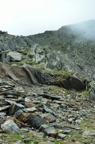
In Peer’s text this magnificent stone pine, Pinus cembra (also known as the Arolla or Swiss stone pine) might stand as a symbol for the Romansh languange and culture and its perserverence (ca. 60.000 people speak one of its dialects). It reminds me of the piece of wood that was cut from a trunk in an alpine moor at 2363 masl in Las Gondas. The Las Gondas moor lies just below the Fuorcla da Tasna, above the Lower Engadin valley. Because a sample taken from the tree trunk could be dendrochronologically dated, we know it grew and grew old here over eight and a half thousand years ago. But already almost 2000 years before that Arolla pine grew here, as needles from that time have been found in the Las Gondas moor.

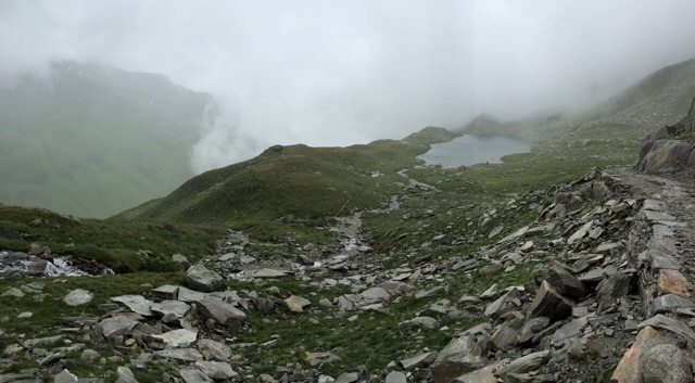
If you have never been there, you should visit the Tamangur forest on the southern side of the Lower Engadin valley. It is fantastic to walk through this open forest high in the Alps, a forest made up almost exclusively of Stone pines. Alive there is a softness about them, with their many small bundles of each five needles. But they can also appear almost archaic, their bare roots arching into the soil below. There is not much undergrowth, low bilberry bushes and alpenroses, the ground soft with needles, moss and grass.

Die knochenweissen Arven von Sursass, im Hintergrund der Piz Lindard bei Lavin. (Foto: Rudolf Grass, Zernez) Bild: Simon Schmid Aus Ganzoni in Der Bund 02.01.2015

Die knochenweissen Arven von Sursass, im Hintergrund der Piz Lindard bei Lavin. (Foto: Rudolf Grass, Zernez) Bild: Simon Schmid Aus Ganzoni in Der Bund 02.01.2015

Tamangur forest is one of the last of its kind. I am at the moment trying to write an article about the Mesolithic of the Alps of southeastern Switzerland. We know that 10’000 years ago, with the glaciers still retreating, people were already at similar altitudes not far from Las Gondas and they might well have walked in the cool shade of the very Stone pines that shed their needles and left their trunks in Las Gondas. They might have sheltered under the enormous rocks in the Plan da Mattun and have rested on the bare, bleached bone roots and trunks of these ancient trees.

Literature:

Dietre, B., Walser, C., Lambers, K., Reitmaier, T., Hajdas, I., Haas, J.-N., 2014. Palaeological evidence for Mesolithic to Medieval climatic change and anthropogenic impact on the Alpine flora and vegetation of the Silvretta Massiv (Switzerland/Austria). Quarternary International 353, 3-16.

Ganzoni., A., 2015, Aufgetaucht: «Das verborgenere Engadin». Fundstücke aus dem Schweizerischen Literaturarchiv: Eine Fotokarte des Engadiner Schrifstellers Andri Peer, in: Der Bund 02.01.2015  (last visited 16.01.2015)

Nicolussi, K., 2012. Jahrringdaten zur Früh- und mittelholozänen Baumgrenze in der Silvretta, in: Reitmaier, T. (Ed.), Letzte Jäger, Erste Hirten. Hochalpine Archäologie in der Silvretta. Amt für Kultur, Archäologischer Dienst Graubünden, Chur, pp. 87-100. (PDF of an older version).

Reitmaier, T., 2012. Letzte Jäger, erste Hirten. Alpine Archäologie in der Silvretta 2007-2012, in: Reitmaier, T. (Ed.), Letzte Jäger, erste Hirten. Hochalpine Archäologie in der Silvretta. Amt für Kultur, Archäologische Dienst Graubünden (ADG), Chur, pp. 9-65.

impressionen 2007-2012

It is already a few years ago that I took part in the fieldwork part of the “Silvretta Historica” project of my friend Th. Reitmaier. The fieldwork has been completed and now it is time for post-excavation work and once every while to look back at the great archaeology and wonderful times we had in the Alps on the Swiss-Austrian border.
But, looking to the future, today I met with another friend to talk about starting a new field project in the near future. Exciting things on the horizon!

Rückwege Blog

impressionen_07-12

View original post

Ski piste archaeology, elusive hunter-gatherers and WWI – Traversar VIII

Time to finally write a last “Traversar” post for this year. There are really two sides to our Passes of the Grison Project. Mostly we do inventory related work. We survey the study areas and record any archaeological sites we discover. There is of course a research element to this. The archaeology of many of the regions we study is not very well-known and anything we discover increases our knowledge of the (pre-)history of the region. We don’t excavate, though. We do make small test-trenches of up to ca. 30×30 cm or take auger cores at most sites we find. These allow us to evaluate the stratigraphy and if we are lucky we might find artefacts or, more likely, we can take charcoal samples for radiocarbon dating.

Recording probably 20th century military structures near the Passo Bornengo.

Recording probably 20th century military structures near the Passo Bornengo.

The sites we find become part of the cantonal database of archaeological sites. This again allows the archaeological service to react when sites become threatened by building plans, erosion, ploughing etc. Our work in the Oberalppass area is an example of this. You might not realise it, but mountain slopes get bulldozed quite properly these days before they become a ski-piste. Also, pylons for lifts, water pipes for artificial snow-installations, foundations for your favourite ski bar and artificial lakes to hold water for making artificial snow, they all need substantial holes in the ground. A major expansion of the Andermatt-Sedrun Ski Arena is planned. And the Disentis 3000 ski area plans to install a whole system of snow blowers to guarantee its guests a good snow cover. Such plans will become ever more common with increasing winter temperatures and should get appropriate archaeological attention throughout the Alps.

Passo Bornengo. Probable military structures (20th C).

Passo Bornengo. Probable military structures; terracing & building remains (20th C).

So on Wednesday, we surveyed the relevant parts of the Disentis 3000 ski resort. Rudolf Büchi kindly took the time to explain the current plans and let us use the ski lifts to save time. Up in the ski area we were surprised to find quite a few hitherto unknown archaeological sites as well as further archaeologically interesting areas. It will be very very interesting to have a more detailed look at the finds we made and see the dates we get from the charcoal samples we took. Other areas, however, have already been heavily disturbed by previous building activities.

The days after this we were lucky the weather got a bit better. We turned our attention to the upper part of the Val Maighels and the Val Strem. In both valleys we recorded a number of building remains, which may relate to transhumance activity of Medieval or post-Medieval date. One of these, near the Chrüzlipass in the Val Strem, might well be much older. Very exciting. Hunter-gatherers and shepherds remained rather elusive, as so often. However, both on the Passo Bornengo and the Chrüzlipass we were surprised to find substantial building remains. These are almost certainly military, probably part of the fortifications made during the WWI. Later 20th century military structures are often well recorded, but few records exist of these WWI fortifications. Although Switzerland was neutral during WWI, mobilisation did take place and many passes were fortified. The canton of Graubünden/Grison has started to record some of these, hopefully other cantons with strategic passes will follow this example soon.

Val Maighels, near Passo Bornengo.

Val Maighels, near Passo Bornengo.

The finds we made in these two valley reflect the situation we found the rest of the week as well. Despite the not ideal weather, we have been able to do almost everything we wanted. Also, our expectations based on our desk-based work have been fulfilled. So also methodologically, we seem to be on the right track. Concerning those elusive hunter-gatherers, perhaps they did not leave many traces, perhaps these can only be found with more intensive surveying and more test-trenching.

Traversar VII – dodging the clouds

Tuesday evening and I am staring out at the clouds that are slowly filling the valley top to bottom again. It has been a bit of a fight with the weather so far. We had a good day on monday, though. At least archaeologically. Our hunting grounds were a side valley of the Val Medels, which culminates at the Lukmanierpass. A lake high up at the end of this valley caught our attention. Such lakes have long been of interest to shepherds and especially to Mesolithic hunter-gatherers. We were lucky enough to survey its shores in sunny weather, but weren’t lucky enough to find any archaeological remains there.

20140729-215434-78874993.jpg

Lai Blau, 2448 masl, looking towards the Lukmanierpass.

After a picknick lunch we turned our attention to the valley flanks where our deskbased work, esp. with old maps and arial photos, had shown we should expect the remains of huts and animal pens. It quickly became clear we were right. However, the weather turned, but we stuck it out in the rain and recorded a number of transhumance related building remains. We even located a potential hearth of these elusive hunter-gatherers underneath a rockshelter. When people used this probable hearth we will only know once we have dated the charcoal samples we took.
Today we dodged the clouds, as it turned out to be an office day. With the low clouds and at times heavy rain it would have been impossible to do any useful surveying. But our documentation is finished to perfection now and we got to enjoy the sights of Disentis/Mustér, where we are based.

Traversar VI – a day in the clouds

A day in the clouds. Now that might sound rather romantic and such a day does give you very dramatic views. Sadly, however, it is also rather wet and it limits your view, not very handy when doing archaeological survey work. It is hard to orientate yourself in such conditions and it isn’t easy to get a good impression of the landscape and how it might have been used by people in the past.20140727-175430-64470093.jpg
We were in the Oberalppass region today. Definitely a region with high archaeological potential. There seem to be many remains of past transhumance activity. These probably date to medieval or post-medieval times. What was a little more surprising were the remains of buildings and other structures which might have military origins. We expect at least some of these might be related to fortifications from WWI. That would be quite exciting, as such remains are not as well recorded as one might expect.

With the imminent building activity for the connection of the Andermatt and Sedrun ski areas, it is important any archaeological remains are located, so they can be studied before construction work starts.


20140727-175430-64470321.jpg

20140727-175430-64470792.jpg20140727-175428-64468688.jpg

20140727-175429-64469193.jpg

Alpine archaeologist in action. Photographing medieval/post-medieval building remains. Above the Oberalppass, Switzerland.

And a few more nice photos from one of my colleagues:

20140727-181506-65706814.jpg

20140727-181507-65707067.jpg

Lead bullet. Above the Oberalppass, Switzerland.

20140727-181506-65706953.jpg

20140727-181506-65706690.jpg
That’s it for today. I promised to make potato-salad and people are getting hungry!

P.S. These photos are all made with mobile phone cameras. We only have internet access over our phones, which is how I write these posts as well.

Preparing for fieldwork – Traversar IV

Het is stil in Nederland.

“Mr. President,

We are here to discuss a tragedy: the downing of a commercial airliner and the death of 298 innocent people. Men, women and a staggering number of children lost their lives, on their way to their holiday destinations, their homes, loved ones, their jobs or international obligations. Since Thursday I’ve been thinking how horrible the final moments of their lives must have been, when they knew the plane was going down. Did they lock hands with their loved ones, did they hold their children close to their hearts, did they look each other in the eyes, one final time, in a wordless goodbye? We will never know.

The demise of almost 200 of my compatriots has left a hole in the heart of the Dutch nation, has caused grief, anger and despair. Grief for the loss of loved ones, anger for the outrage of the downing of a civilian airplane and despair after witnessing the excruciatingly slow process of securing the crash site and recovering the remains of the victims. …”

Speech to the UN Security Council by Frans Timmermans, Minister of Foreign Affairs, the Netherlands

It seems to me lately we are confronted again and again by waves of news of people suffering from violent conflicts they might have no active part in. News from Syria, Nigeria, Afganistan, Sudan, Irak, Palestine and many other places across the globe, like the Ukraine. And now the Netherlands – the country I was born and grew up in – mourns, is quiet.

Many of us are lucky. Our lives continue, almost as usual. And I have been feeling a little guilty about looking forwards to and preparing for our next fieldwork campaign of the Traversar Pässe Project. But perhaps we owe it to our loved ones, all those who do not have the possibility to do so and who have passed too young, to make the most of our lives, to enjoy it and make the best of it.

Remains of one of the many old incarnations of the road leading from the north over the San Bernardinopass.

Remains of one of the many old incarnations of the road leading from the north over the San Bernardinopass.

Last year a small team commissioned be the Archaeological Service of the canton of the Grison (ADG), started a survey project of the main passes of the Grison. We started with the San Bernardino region. This weekend we head into the field again. The Oberalp– and Lukmanierpasses are the main focus of this year’s campaign. This is all the more pressing as large construction works are planned for the near future, which should lead to the connection of the skiing areas of Andermatt and Sedrun.

Not much is known about the archaeology of the region yet. But with these important passes and the important Monastery in Disentis/Mustér the region has had a prominent role in more recent history of the Alps of Central Switzerland. Also the regions in the cantons of Uri and Ticino west of the Oberalppass and southwest of the Lukmanierpass have been studied during the past 2-3 decades by the Leventina (Hess et al 2010) and the Gottthard Projects of the University of Zürich (Primas et al 1992) and a rescue archaeological project in the Urserenvalley (Urner Historisches Neujahrsblatt 2013, e.g. Auf der Maur & Cornelissen 2013). We thus expect our study area to have much archaeological potential. The first deskbased work seems to confirm this.

Simultaneously, the documentation of remains of WWI fortifications near the Umbrailpass will continue. We will also host the kAltes Eis-Project whose team will undoubtely make us run up to many faraway ice patches high up the end of some valley to look for archaeological remains.

We will have limited internet access in the Vorderrheinvalley, but hope to report whenever possible of our progress. Most likely here or on twitter (hashtag #traversar). You might also want to keep an eye on the Alpine Archaeology facebookpage.

Heading to the Vorderrhein we will be gratefull that we are able to continue doing such fascinating archaeological work in a beautiful part of the world with great friends and colleagues and fab archaeologists.


AUF DER MAUR, C. & CORNELISSEN, M. 2013. Die spätmesolithische und bronzezeitliche Fundstelle Hospental-Moos. Ein Einblick in das urgeschichtliche Urserntal. Historisches Neujahrsblatt, 68, 37-84. (As well as furhter contributions in this volume).

HESS, T., REITMAIER, T., JOCHUM ZIMMERMANN, E., BALMER, A., DOBLER, I. & DELLA CASA, P. 2010. Leventina – prähistorische Siedlungslandschaft. Archäologischer Survey im alpinen Tessintal und entlang der Gotthardpassroute 2007/2008: kommentierter Katalog. Jahresbuch der Archäologie Schweiz, 93, 173-193.

PRIMAS, M., DELLA CASA, P. & SCHMID-SIKIMIC, B. 1992. Archäologie zwischen Vierwaldstättersee und Gotthard: Siedlungen und Funde der ur- und frühgeschichtlichen Epochen, Bonn, Habelt


Traversar III – a photographic record

Autumn has arrived in the Alps. The grass is losing its green lustre, leaves are slowly turning brown, farmers have moved their life-stock from alpine summer pastures down into the valleys and snow is expected later this week. Time to have a first cautious look back on this summer’s archaeological activities in the Swiss Alps.

I already wrote once about a small project we, a select team of expert alpine archaeologists (of course), started with the aim to study the archaeological remains at a number of the most important passes in the Grisons. This summer we were mostly active in the San Bernardinopass region. We also surveyed some areas in the Upper Engadin Valley which are to be subject to development in the near future. (For this we were officially commissioned by the Archaeological Unit of the Canton of Graubünden.)

We were lucky with the weather and were able to do all we set out to. We had some interesting results and although dating is difficult at this stage, we expect our finds to be both of medieval/early modern as well as prehistoric dates. While we are cleaning up the documentation, analysing the results and waiting for the C14 dates, I thought I posts some photos giving an impression of the fieldwork.

And if you are interested in the archaeology of the Alps, why not have a look at the alpine archaeology blog? Students of the Alpine Archaeology: tools and techniques e-learning course at the Universität Zürich will be blogging here this semester (DE).

During the fieldwork we discussed archaeology and bandes dessinée. We talked about the book Le soleil des morts, by comic artist A. Houot and archaeologists A. Gallay. (I believe it is not in print anymore.) I would be very interested in hearing about other good examples (in any language), so do get in touch!

Image

Traversar II – a first glimps

image

Looking down on the northern side of the San Bernardino pass

We have had a very good week in the field so far. Weather, food and company have been great. The archaeology has not been bad either. As soon as I have internet again, there will be more news!

Traversar – Surveying the passes of Graubünden

Outtake from the IVS-GIS. © http://map.geo.admin.ch

Outtake from the IVS-GIS. © http://map.geo.admin.ch

Thankfully, I am allowed outside again next week. With a small international and select group of crack archaeologists – most of us old comrades in arms – we will be starting a three year survey project of some of the main passes in the Canton of Graubünden. The work is commissioned by the Archaeological Service of the Canton of Graubünden. A second leg of the project is the documentation of remains of WWI fortifications. Switzerland remained neutral, but guarded its borders intensely. So far the archaeological community in Switzerland has paid little attention to 20th C archaeology, but it seems right to start studying these now and make the wider public aware of the cultural historical value of these remains and that we should not leave them to private collectors.

Our group, will be focussing on prehistoric sites, though. We are starting with the region of the San Bernardino pass, the Julier pass and an area on the northern slopes of the Upper Engadin valley. Finds are known from both near / on the Julier and San Bernardino passes, but there are uninvestigated areas around both, and e.g. on the Julier archaeological focus so far has been almost solely on the Roman Period. If we have the possibility (internet access), we will try to keep you posted on the fieldwork here, so stop by once every while. We are very excited about getting started!